Abstract
In Japanese agriculture, the division of cultivated land into main land and ridges is an important element. According to data from 2022, the total area of farmland nationwide is 4.33 Mha, of which mainland areas account for 4.15 Mha. On the other hand, Hokkaido has the largest area of ridges at 18.2kha. Past trends show that cultivated land in the mainland accounts for the majority of the total, with the area of ridges varying from region to region. In addition, the relatively small area of the ridges suggests that local agricultural activities are predominant and the ridges are used to meet limited demand in specific areas. These factors are important in understanding Japan’s agricultural structure and regional characteristics.
Total of rice fields and farmland (main data).
The field management system in Japanese agriculture has undergone various changes between 1956 and 2022. In 1961, the country recorded a peak of 6.09 Mha, but since then it has gradually declined and is currently shrinking to just 71.1% of its peak. The reasons for this decline include the conversion of farmland to other uses due to urbanization and industrialization, and increased efficiency of arable land due to improved agricultural productivity. Another factor may be the decline of agriculture due to an aging population and a lack of successors. This trend is changing Japan’s agricultural structure and highlights the need for optimized land use and sustainable agricultural policies.
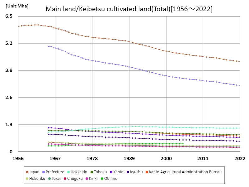
The maximum is 6.09Mha[1961] of Japan, and the current value is about 71.1%
Total farmland (by prefecture).
Based on data from 2022, Hokkaido has the largest total cultivated land in Japanese agriculture, at 1.14Mha. This is the highest value compared to historical data, suggesting the influence of regional characteristics and agricultural policies. Due to the difference in area between the main land and the banks and the characteristics of each region, agricultural methods and activities appear to differ in each area. In addition, analyzing data by prefecture will reveal differences in agricultural structure between regions and issues specific to each region. These data will provide important reference information for regional agricultural policies and resource allocation.
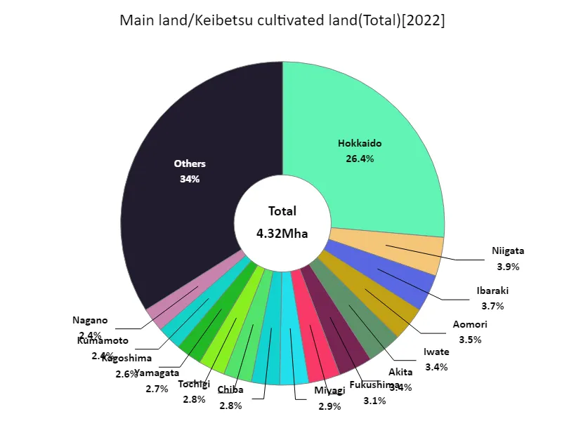
The maximum is 1.14Mha of Hokkaido, the average is 92kha, and the total is 4.32Mha
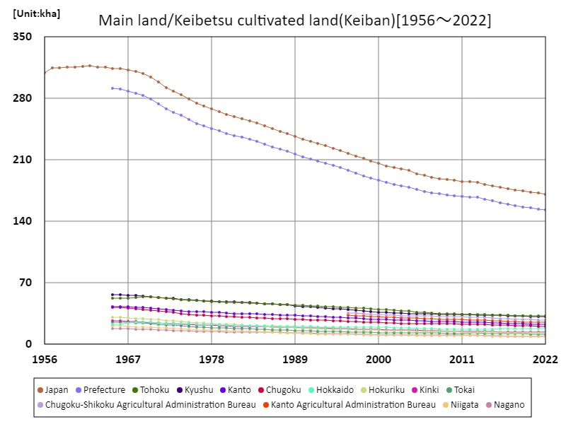
Homeland of farmland (main data).
The land use statistics for Japanese agriculture have undergone various changes between 1956 and 2022. The maximum area of 5.77Mha was recorded in 1961 and has since declined gradually to currently be 72% of its peak area. The reasons for this decline include the conversion of farmland to urbanization and industrialization, the efficiency of arable land due to improved agricultural productivity, and the decline of agriculture due to an aging population and a lack of successors. In addition, the characteristics of each region, which differ depending on the country’s land area and geographical conditions, also have an impact. These changes are transforming Japan’s agricultural structure and point to the need for optimized land use and sustainable agricultural policies.
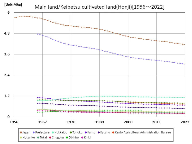
The maximum is 5.77Mha[1961] of Japan, and the current value is about 72%
Rice field and farmland borders (by prefecture).
Based on data from 2022, Hokkaido has the largest amount of cultivated land per bank in Japanese agriculture, at 18.2kha. This is the highest value compared to past data and reflects Hokkaido’s vast farmland and unique agricultural environment. Keihan tend to be relatively small in area compared to the main land and are used to cater for demand in specific areas. In addition, analyzing the data by prefecture reveals differences in the use of ridges and agricultural characteristics between regions. These data will provide important reference information for regional agricultural policies and resource allocation.
The maximum is 317kha[1962] of Japan, and the current value is about 54%


Comments